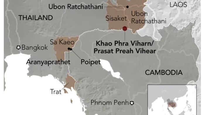
Clashes between Thailand and Cambodia came to a halt after a five-day battle in July that resulted in numerous casualties, as reported by Nikkei Asia.
ASEAN aims to establish a broader ceasefire during its upcoming summit in Kuala Lumpur on October 26, with the presence of U.S. President Donald Trump. However, tensions persist along the border without resolution.
In Thailand’s Sa Kaeo province, hundreds of Cambodians disregarded orders to vacate Ban Nong Ya Kaeo and Ban Nong Chan — two disputed villages where Cambodian checkpoints were destroyed by Thai forces in July. Despite being fenced off with razor wire and surveilled by floodlights and CCTV, the Thai military has not enforced the eviction. A senior Thai army officer told Nikkei Asia, “That is the governor’s deadline, but we have our own.”
The border conflict dates back over a century. Thai historian Charnvit Kasetsiri noted in Preah Vihear that the Siamese-Cambodian border was partially delineated based on a 1904 map sketched by a supposed joint committee of Siamese and French surveyors. Siam did not contest the map, and during King Vajiravudh’s reign, a French map became Siam’s official map.
Cambodia later brought the issue to the International Court of Justice in the 1960s concerning the temple known as Khao Phra Viharn in Thailand and Prasat Preah Vihear in Cambodia. The ruling favored Phnom Penh, leading Bangkok to be cautious of international arbitration thereafter.
The 817-kilometer border remains partially defined, with several of the 73 French-era markers either missing or disputed. In Ta Phraya district, only the locations of markers 32 and 37 are agreed upon; markers 33 to 36 are still in dispute, and one is completely missing.
Nikkei writes that mapping discrepancies continue to complicate demarcation. Thailand utilizes a 1:50,000-scale chart, while Cambodia uses a 1:200,000 version. Historian Thongchai Winichakul, author of Siam Mapped, stated, “A millimeter could mean three to four kilometers, and the two maps are not compatible due to their methodology.”
Maj. Gen. Winthai Suwaree, spokesperson for the Royal Thai Army, defended Thailand’s map as “more accurate than the 1:200,000 map,” citing aerial photos as evidence. He told Nikkei, “Originally there were no inhabitants. More people have gradually moved in every year, and so we must get serious about it.”
The primary trade gateway between Aranyaprathet and Cambodia’s Poipet, closed since July, is not expected to reopen this year.
Former Thai foreign minister Tej Bunnag emphasized in a 2020 memoir the necessity of scientifically demarcating the border from the Gulf of Thailand to Ubon Ratchathani. He suggested that placing markers in Trat province would enable both countries to negotiate the sharing of natural gas off the Thai-Cambodian coast, similar to the arrangement with Malaysia.
Progress in resolving the border issue has been hindered by political caution and increasing nationalism. Thongchai remarked, “As long as both sides continue to make unrealistic claims and disregard scientific facts, the best solution is to maintain the status quo. Many border demarcation committees in Thailand employ this tactic because while the issue can be resolved scientifically, it remains a political challenge. It may seem unconventional, but it is a strategic approach.”
Loading recommendations…

