

Meteorologist Mike Masco predicts an active storm pattern for the Northeast and Mid-Atlantic from New Year’s Day to mid-January.
“After analyzing the pattern, I’ve identified three key features that suggest a series of storms for the Northeast and Mid-Atlantic, including the possibility of two major snow events and several smaller ones,” Masco shared on X.
Masco, a meteorologist for PIX11 News in New York City, specializes in the Northeast and Mid-Atlantic regions.
He detailed what the post-New Year pattern could mean for each region:
• West-based negative NAO (Greenland block) slows the pattern and shifts the jet stream, leading to possible coastal storms. A New Year’s Day event is possible.
• Rockies ridge directs storm energy south of NYC and Philly, increasing snow potential.
• Western Atlantic ridge keeps systems near the coast, favoring traditional snowstorms.
Timing: The pattern starts around New Year’s Day and continues into mid-January. A clipper system on New Year’s Eve may bring light snow, with redevelopment chances toward Boston.
Here is Masco’s forecast map:
Peak winter weather is still a few weeks away.
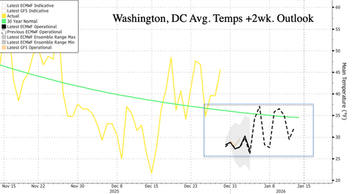
Washington, DC’s Heating Degree Days will be above average, indicating higher NatGas demand and prices.
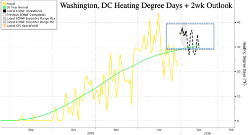
NatGas prices rose in November and December due to cold weather patterns in the US East.
Loading recommendations…