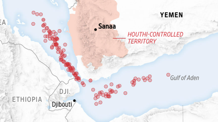
In the Middle East, it has been reported by The Wall Street Journal that Russian intelligence officials have allegedly provided Iran-backed Houthi rebels with geospatial intelligence (GEOINT) data for strategic planning and operational decision-making to attack Western vessels in the critical maritime chokepoint of the southern Red Sea.
According to the report, the Houthis, who began their attacks late last year over the Gaza war, have been using Russian satellite data for their strikes, as confirmed by a person familiar with the matter and two European defense officials. The data was reportedly passed through members of Iran’s Islamic Revolutionary Guard Corps, who were embedded with the Houthis in Yemen.
While specifics about the GEOINT data provided by Russia to IRGC/Houthis were not mentioned, it is speculated that the assistance may have included satellite imagery and potentially the use of unmanned aerial vehicles for reconnaissance and weapon guidance purposes.
This alleged Russian assistance may explain the expansion of the Houthi threat coverage across the southern Red Sea and Gulf of Aden, with more than 100 ships being targeted since November 2023, resulting in the sinking of two ships and the hijacking of another.
According to WSJ, the Russian assistance in the Middle East signifies a shift in strategy, with Putin strengthening ties with Iran while distancing from Israel and Prime Minister Benjamin Netanyahu. The lack of strong foreign policy from the Biden-Harris administration has exacerbated tensions in the region, leading to disruptions in global shipping and supply chains.
The current geopolitical landscape has raised concerns about the potential for escalated conflicts, with the US facing challenges in Eastern Europe, the Middle East, and the Taiwan Strait. The call for strong leadership in times of crisis is evident, emphasizing the need for a decisive approach in addressing global security threats.
Loading…

